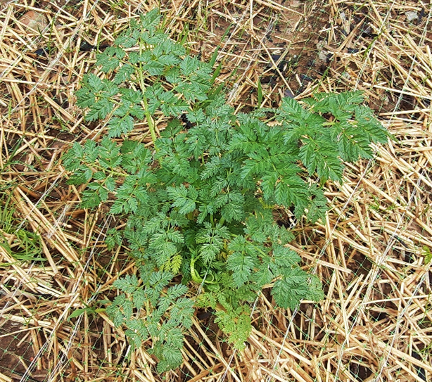
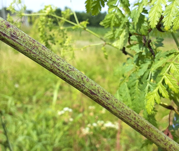
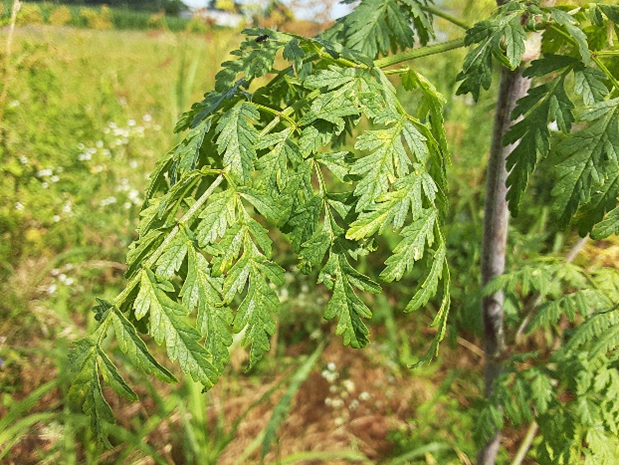
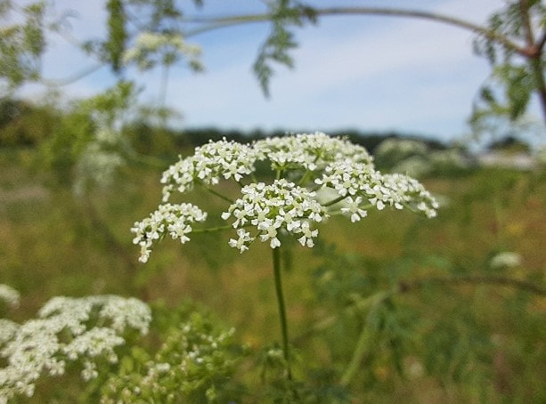
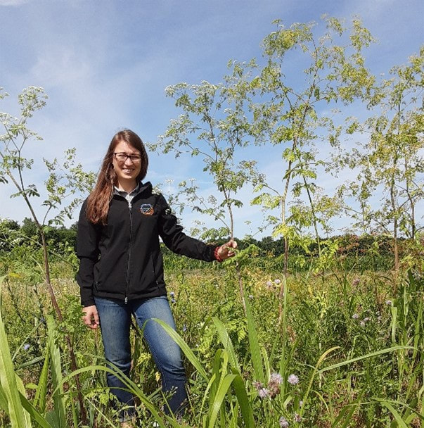
By Holly Utrata-Halcomb
As the weather warms up and rainfall increases this time of year, the Ohio Department of Agriculture Division of Soil and Water Conservation would like to remind producers and nutrient applicators of laws and restrictions on manure application. Please keep in mind that these restrictions are year round. Signed into law by Governor John R. Kasich in July 2015, these measures clarified and enhanced the restrictions on manure application. They include: When the local weather forecast for the application area contains a greater than fifty percent chance of precipitation exceeding one-half inch in a 24-hour period. Producers are reminded it is their responsibility to research and make a copy of a local forecast or the 24-hour precipitation forecast. Other verifiable sources of weather prediction are acceptable. When the top 2 inches of the soil are saturated from precipitation; On snow-covered or frozen soil. Restrictions do not apply if: The manure is injected into the ground Manure is incorporated within 24 hours of surface application, using a tillage tool operated at a minimum depth of 3-4 inches The manure is applied onto a growing crop; The chief of the Division of Soil and Water Conservation has provided written consent for an emergency application. Contact the division in case of an emergency. All producers are reminded to use best management practices when applying manure and follow USDA NRCS Field Office Technical Guide Standard 590. This includes but is not limited to following manure application rates, set back requirements and considering waterways and streams before applying manure. The Ohio Department of Agriculture has an online tool designed to help nutrient applicators identify times when the potential nutrient loss from a fertilizer or manure application is low. The Ohio Applicator Forecast takes data from the National Weather Service, predicting potential for runoff to occur in a given area. The forecast takes snow accumulation and melt, soil moisture content and forecast precipitation and temperatures into account, giving farmers substantial information when they are making nutrient application decisions. For more information about manure application, producers and applicators can contact the your County Soil & Water Conservation District or NRCS agent.
0 Comments
By Holly Utrata-Halcomb
The Hamilton County Soil & Water Conservation District Cover Crop Demonstration and Study Project was initiated in September 2014, funded by an Ohio Farm Bureau Grant. Initially, four of the County’s largest farmers responded to an advertisement looking for volunteer participants. The responding farms were; Heyob Farms, Knollman Farms Inc., Joseph Hoerst Farms and Leonard Minges Farm. All farms are located in Crosby and Harrison Townships, in the Northwest section of Hamilton County, Ohio The overall goals of the cover crop study were to illustrate to the farmers the benefits of using cover crops. Establishing four demonstration sites by some of the largest and most respected farmers in the County so that surrounding farmers could observe the results and hopefully replicate the use of cover crops. Goal Attainment 1. Reducing erosion on fields after harvest through spring. Aerial seeding proved to be an expensive and a risky way to spread the seed. Although weather is always a factor, the lack of seed/soil contact proved to be a larger barrier. Direct seeding by drilling or disking was a far more successful method of planting. The dense regrowth of the Cereal Rye in spring 2017 and 2018 definitely succeeded in this goal. 2. Retaining Nitrogen and other micronutrients in the soil for the following year’s crop. A true sign of success would be to see the farmers Nitrogen inputs reduced in the spring. Results – The results of Nitrogen values were mixed. 59% of the fields saw an overall increase in Nitrogen; 30% saw a decrease and 11% remained about the same. 3. Illustrate the increase in soil health with the addition of extra carbon from the spent cover crop. The Heyobs, Minges and the Knollmans fields improved overall in soil health. Overall, 94% of the fields had an increase of soil health over the 4 year study. 2% had a decrease in soil health and 2% remained about the same. These soil health results mark the biggest success of this study. 4. Demonstrate the increased water holding capacity of soil by adding additional plant residue via cover crops. The additional plant residue on the soil surface served as a mulch, increasing water holding capacity. This was especially beneficial on sandy soil. Repeated planting of cover crops increased this capacity. The Knollman’s in particular felt this increased their overall yields. Results – Both the Heyobs and the Knollmans acknowledged the increase water holding capacity of the soil. Both farmers plan to plant an increased acreage of cover crops in fall 2018. The Knollmans harvested 5 acres of Cereal Rye to save the seeds for planting. Acknowledgement of Support In addition to Ohio Farm Bureau for supplying the grant for this project and Hamilton County farm Bureau for holding and distributing these funds, I want to thank the following individuals and organization for assistance and support of this study. - Rick Haney, PhD, Soil Scientist, and his team at Grassland Soil and Water Research Laboratory, USDA- ARS, 808 East Blackland Rd., Temple, TX 76502. Dr. Haney and his staff performed the Solvita Method for soil fertility testing on all samples from our test fields. - John Williams, District Conservationist, Natural Resource Conservation Service (NRCS) and William Cook, Soil Scientist, (NRCS) were both instrumental in providing aerial photos and maps for this project. - All of the farmers who participated for their cooperation and time spent on this cover crop project. By Adam Lehmann
In Hamilton County, we are very fortunate to have a wealth of data on the health of our local creeks and rivers. With respect to the quality of the water flowing through our streams, Southwest Ohio has one of the largest networks of volunteer water quality monitoring programs in the country. Volunteer water quality monitoring programs perform a critical function of monitoring water quality more frequently (monthly in southwest Ohio) than that for which most local governments are able to budget. This is particularly important with monitoring water quality which, unlike metrics of aquatic wildlife and physical habitat, may be expected to fluxuate significantly over short periods of time in response to stormwater runoff or other pollution events. Our local volunteer water quality monitoring programs also make their data easily accessible to the public at StreamBank.info. But, water quality is not the only determinant of stream health – if suitable physical habitat does not exist in a stream, that stream cannot support a healthy ecosystem no matter how “good” or “pure” the water. Our urban and suburban landscapes are built in ways that alter the natural flow of water through the landscape. Resulting “flashy stream flows” cause excessive streambank erosion, which in turn, result in large amounts of sediment filling in the void-spaces between rocks upon which aquatic wildlife rely for shelter. These urban/suburban altered flow patterns also result in streams that used to flow year-round drying-out; this wide-spread problem constitutes a complete loss of aquatic habitat. Another major cause of habitat degradation is clearing of trees around streams – robing the streams of temperature regulating shade and critical inputs of food sources and habitats in the form of leaf litter and woody debris. Beginning in 2011, The Metropolitan Sewer District of Greater Cincinnati began contracting the Midwest Biodiversity Institute to assess the health of our local creeks in rivers. Assessments were conducted at hundreds of sites throughout Hamilton County. This was a huge effort that took 4-years to complete. In 2016, MSD began another 4-year follow-up study to assess changes over time. The product of these assessmentsis a wealth of information on the chemical, physical, and biological health of our local streams. This effort has revealed that nearly 65% of the County’s streams are impaired biologically. Together, the high frequency volunteer water quality data and the professional biological assessments, provide a key insight into the primary factors affecting the health of our local creeks and rivers. When these data are viewed side-by-side on the accompanying maps, we see that, while water quality is pretty good in Hamilton County (lots of green and blue dots on the Volunteer Water Quality Monitoring Map), the health of aquatic wildlife continues to suffer (lots of red and yellow dots on the Aquatic Life Use Attainment Map). This tells us that the primary factor impacting aquatic wildlife in Hamilton County is not water pollution but degradation of physical habitat (including flow patterns) caused by the way that we build our urban and suburban environments. This finding is consistent with state-wide and even global statistics on causes of “stream impairment”. In Ohio EPA’s 2018 Integrated Report, they report that three of the top five (including the top two) causes of biological “impairment” are related to physical habitat. Similarly, in 2018, the World Wildlife Fund’s Living Planet Reportestimated that there has been an 83% decline in population abundance (number of induvial) of freshwater animals across the globe between the years of 1970 and 2014. Eighty-three percentin 45-years – that’s huge! So, what was found to be the most significant cause of this decline? You got it – habitat loss/degradation. In the United States, we have come a long way from the days of burning rivers. Since the 1972 amendments to the Federal Water Pollution Control Act (known as the Clean Water Act), the water quality in our creeks and rivers has improved dramatically largely due to regulation of discharges from industrial facilities and wastewater treatment plants. But, progress in improving stream health has leveled-off (remember: an estimated 65% of Hamilton County’s streams are impaired biologically). Continued restoration of stream health will require a re-focusing on factors that are impairing the physical habitat within our creeks and rivers. In addition to government-led installation of large-scale stormwater management projects, addressing impairments to in-stream physical habitat at the landscape scale will require public policy to put in place meaningful incentives for private property owners to better manage stormwater and re-forest our riparian corridors. |
AuthorsStaff and friends of the Hamilton County Soil & Water Conservation District in Ohio ArchivesCategories |